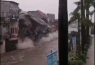
During a year in which Bali is experiencing unprecedented rainfall, the Island has again been hit by intense rainfall across wide parts of the province since Sunday, 11 February 2026, resulting in new flooding and widespread property damage. Some areas affected by flooding necessitated the temporary evacuation of specific tourist and residential areas.
As reported and summarized by RadarBali.com, data maintained by the Bali Provincial Disaster Mitigation Agency (BPBD), updated through Tuesday, 24 February 2026, recorded 76 “disaster location” Island-wide, with the worst-affected areas located in the City of Denpasar.
Three days of almost continuous rain have “literally precipitated” flash flooding, landslides, and tree falls.
76 areas of damage and disaster incidents in Bali connected to the current deluge include:
42 Flood Zones
5 Landslides
2 Fallen Trees
5 Areas of breached Embankments
1 Mini Tornado touchdowns
Bali’s capital, Denpasar, was the worst affected, with 36 areas recording significant damage from flash flooding in residential areas and along main roadways that were momentarily submerged by water at depths of 30 and 80 centimeters.
Damage in Denpasar was caused by extreme rainfall, which was sadly exacerbated by clogged and overflowing drains and runoff from upland areas surrounding the Capital.
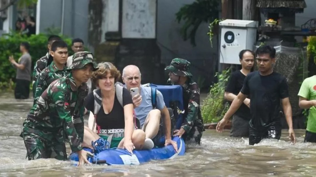
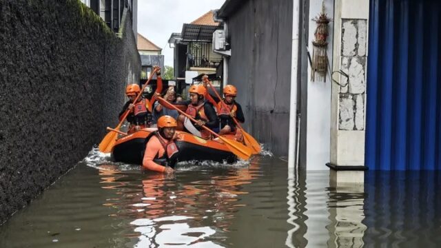
“We’ve received many reports confirming that many roads and residential areas in Bali were flooded. Fortunately, there have been no casualties, and everything is under control,” said the Bali BPBD Chief, I Gede Teja, in Denpasar on Tuesday, 24 February 2026.
Officials continue to pay special attention to the Tukad Badung River, which flows through Denpasar’s city center and is flowing at near-overflow levels. As a result, residents living along the river have been cautioned to remain on alert, as the threat of flooding and embankment overtopping persists should the current period of heavy rains persist.
BMKG Warning
The Bali branch of the Meteorology, Climate, and Geophysics Agency (BMKG) has issued a “standy” (Siaga) alert covering the regencies of Badung, Jembrana, and Tabanan in the case of further periods of heavy rain. Meanwhile, the Capital City of Denpasar and the regencies of Bangli, Buleleng, Gianyar, Karangasem, and Klungkung are under a state of “alert” (Waspada).
BMKG is warning the public to be on the lookout for dangers posed by strong winds along Bali’s coastal areas. The public is urged, during periods of inclement weather events, to NOT take shelter under large trees, which could collapse due to current weather conditions; to avoid congregating near rivers; and to be on the alert in mountainous areas subject to potential landslides.
Current Complete List of 76 Disaster Points in Bali
Kota Denpasar (36 Disaster Points)
The areas of the city worst affected were flooded by water up to 80 centimeters deep.
Flood Areas
Jl. Griya Anyar (Simpang Dewa Ruci): 80 cm
Jl. By Pass Ngurah Rai No. 259, Sanur: 50 cm.
Jl. Tukad Badung 14 Blok C, Renon: 50 cm.
Jl. Raya Puputan, Renon:50 cm.
Jl. Hangtuah, Gang Mawar 9, Sanur: 50 cm.
Jl. Tegal Wangi Gang Tegal Jaya, Sesetan: 40 cm.
Jl. Danau Tempe, Sidakarya: 40 cm.
Jl. Tukad Balian, Gg. Babakan Sari: 40 cm.
Jl. Pungutan, Gg. Jasmin, Sanur: 40 cm.
Jl. DI Panjaitan, Renon: 30 cm.
Jl. Raya Sesetan, Gg. Pantusari: 30 cm.
Jl. Tukad Nyali, Gg. V No. 3: 30 cm.
Jl. Pulau Ayu Selatan, Gg. I: 30 cm.
Jl. Sekuta, Gg. Mangga No. 5C, Sanur: 30 cm.
Jl. Taman Pancing Timur, Gg. Lestari: 30 cm.
Jl. Antasura, Gg. Tunjung: 30 cm.
Jl. Pengiasan, Gg. III, Sanur: 30 cm.
Jl. Raya Sesetan, Gg. Jalak No. 5: 30 cm.
Jl. Kerta Dalem Sari, Gg. Kayu Santen, Sidakarya: 30 cm.
Jl. Imam Bonjol, Gg. Air Mancur II: 30 cm.
Jl. Pulau Ayu Selatan, Gg. I (Two Areas): 30 cm.
12 more residential areas, mostly in South and East Denpasar
Additional Disaster Points
Jl. Gn. Payung, Padang Sambian Kelod: – Localized Tornado
Jl. Siulan, Gg. Lely No. 88: – Breached water embankment
Tukad Badung River : Standby Status with river level near maximum flood level
Badung Regency – 20 Disaster Points
Flood Areas
Jl. Kunti, Legian: 50 cm.
Jl. Merpati, Tuban: 50 cm.
Jl. Wana Segara, Jimbaran: 40 cm.
Jl. Campuhan II, Legian: 40 cm.
Jl. Padma Utara, Legian: 0 cm.
There were 12 additional flood areas, mostly in Kuta, Seminyak, and South Kuta.
Other Disaster Events
Desa Kerobokan: Large Fallen Tree.
Jl. Sunset Road: Large Fallen Tree
Uluwatu Area: Landslide
Gianyar Regency – 9 Disaster Points
Several reports of Fallen trees and shifting land formations
Desa Kedewatan, Ubud: Fallen Tree
Banjar Glogor, Lodtunduh, Ubud: Landslide
Desa Tulikup, Gianyar: Fallen Tree
Desa Sumita, Gianyar: Fallen Tree.
Desa Sukawati: Fallen Tree
Kecamatan Payangan: Breached Embankment Senderan Jebol (2 separate incidents)
Kecamatan Tampaksiring: Fallen Tree
Desa Batubulan: Flloded Highway
Buleleng Regency – 7 Disaster Sites
A number of key logistical thoroughfares are blocked by landslides.
Desa Selat, Sukasada: Landslide
Bd. Dapdap Tebal, Desa Tembok, Tejakula: Landslide.
Desa Tukad Mungga, Buleleng: Fallen Tree
Desa Pancasari, Sukasada: Pohon Fallen Tree Blocking Roadway
Desa Gitgit: Small Landslide
Pantai Lovin Beachfront: Fallen Tree Due to Heavy Winds
Kecamatan Seririt: Fallen Wall of Local Residence
Other Areas – 4 Disaster Points
Tabanan (Jl. Ahmad Yani, Kediri): Fallen Tree
Klungkung (Desa Nyalian, Banjarangkan): Fallen Tree
Jembrana (Kecamatan Negara): Overflow of Gutters in Residential Area
Karangasem (Kecamatan Rendang): Small Landslide
Bali BPBD is recommending that people shelter in place during storms and heavy rainfall.
Related Links
RI Tourism Minister Says Floods Will Not Cause Decline in Bali Visitors
Poor Land Use Policies Blamed for Bali’s Floods
9 Dead After Floods Ravage South Bali
Stay Informed on Bali Tourism-Related News: Subscribe to Bali Update